
Segment 4 of the Mountains to Sea Trail journeys through some of the more scenic and strenuous terrains of the Pisgah National Forest. About 11 miles of this section traverses the rugged Linville Gorge Wilderness – from Pinnacle Trailhead to TableRock. Today I explored trails I had never been on before as I continued my trek on the MST. On previous day hikes I had completed the trail from Tablerock to Shortoff , and not too long ago, I did an out and back hike that took me from the Greentown Trailhead (Hwy 181) to Buck Creek.

This was Memorial Day weekend, and I knew that the Tablerock parking area would be crowded. Therefore, I decided to do something different and split my out and back. I parked at the middle of the trail and did two out and backs. FS Rd 210 comes into the gorge area from Gingercake Acres off 181 and it intersects FS Rd 496 in about 6 miles. All of the other trailheads were packed with cars, but this intersection had plenty of parking. By the way, the road is well maintained, but can be dangerous with numerous cars going both directions, so watch your speed.


I knew from studying the maps that the hike up to Tablerock would be more challenging. I decided to do the hike down to Buck Creek first as a “warmup”. For the most part, it is an easy hike down. It is about 3 miles and a descent of approximately 1200′ in elevation. The trail is well marked, abounding in galax, rhododendron and mountain laurel.

Buck Creek campsite is a large level area directly adjacent to the creek. It appears to be a popular spot for camping. One thing I have not mentioned are the resources that I use when I hike. I always carry a paper map with me – because you never know. However, on my phone, I utilize the Far Out App with the MST map. It is a one time purchase, but one I highly recommend. It has been very accurate, and includes details like water locations, campsites, parking, etc. One feature I really like is the Mileage indicator from Clingman’s Dome. By the way, Buck Creek campsite is 223.8miles from the beginning of the MST.

The trouble with going down… is you have to go back up! It’s intriguing how a few miles down seems easy until you turn around and head back. It was not a bad walk back to the car and the middle of my day hike. In fact, by placing my vehicle in the middle, I was able to carry a little less water and food.


From my parking area it was about 3 miles to Tablerock, but it was another 1400′ in elevation gain. The MST takes a sharp turn here and continues down FS496 for about 0.3 miles where it leads into the woods to the left. The path begins its ascent here and in about 0.5 mile it crosses FS210, then the fun begins.

The first part of the ascent from FS210 is just a straight shot without many switchbacks. And as you approach the ridge, the last section is a scramble over a lot of rocks. I am not complaining- in fact, I really love the challenge of the rocky terrain, but I probably should not have taken 3 weeks off previously from hiking. By the time I reached the junction for the spur trail leading to the summit, my legs were burning.

I had reached the point where the MST meets the Table Rock Summit trail, and now I had a decision. The MST does not go to the peak, which is typical because most trails going to summits are spur trails that dead end, and the MST is continuous. I was exhausted, but as I have stated before, this is one of my favorite places and I could not miss going up again and experiencing the views. Inspired by curiosity, I pushed through!

The summit trail is well traveled and beautiful. It is primarily made up of a lot of rock steps as it ascends about 300′ in less than a 0.5 mile. The elevation of Tablerock is 3931′.

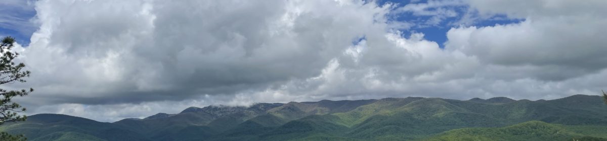
There are many great vista points along the way up, offering spectacular views of the gorge and beyond. Once on the peak, there are many paths to explore, but as I warned in a previous blog about Shortoff, this can be a dangerous place. The Burke County Rescue teams stay extremely active as they rescue people who have made some unfortunate decisions.

The 360 degree views obviously never disappoint. This is one of the places where I am always awed by the wonder of creation and amazed that I am a part of it – ‘wonderfully made’. My prayer and hope is that I can share it, protect it and always be swept away in its wonder.


I was fortunate to get to the summit before the holiday crowds. Even though the forest service roads are a long drive in, the hike from the Tablerock parking lot is very popular during weekends. In a few months the huckleberries will be ripe, and that is always a satisfying treat after making the climb. It is rather bittersweet that this was my last MST hike in the Linville Gorge. However, I will be back.
40 Hike Challenge Blue Ridge Parkway Conserving Carolina Falls Lake Hickory Nut Gorge Hiking Jones Gap State Park Lake Lure Linville Gorge Mountains to Sea Mount Mitchell North Carolina Trails
Thanks as always for your great blog entries! The gorge is one of several areas on the MST that I won’t attempt, so I enjoy living vicariously through your writing and photos.
Wish I could have been there – I really miss a lot of those hikes, although I am still hiking.