
It is difficult to put into words the joy it brings me to be back on the trail, continuing my journey on the Mountains to Sea Trail. This past week I had the pleasure to spend 4 days day-hiking Segment 5 of the MST. I was blessed to have wonderful weather the entire week and my wonderful wife and her parents to assist in drop offs and pick ups. I especially enjoyed a special treat as my father-in-law, Jack Petty, joined me on some of the trail.


DAY 1: Beacon Heights to Julian Price Park
I began day 1 at the Beacon Heights Parking lot – the western terminus of Segment 5. My first day would take me 13.5 miles to Julian Price park, following the Tanawha Trail. The Cherokee name for Grandfather Mountain was Tanawha which means “fabulous hawk”. The trail is marked either with the familiar MST white blaze, the Tanawha white feather, or both.

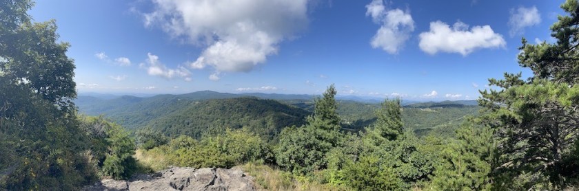
It was a short side trail (0.2 miles) from the parking area to the overlook- well worth the trip to begin my day. Looking west, the peaks of Table Rock and Hawksbill were clearly visible


The trail skirts the Blue Ridge Parkway, rising above and below the parkway on a path that typically consists of rocks and boulders. The bridge over Stack Rock Creek and adjoining steps are evidence of how much work was required to build this trail.

In less than 2 miles, the MST passes under the Linn Cove Viaduct. Even though the Blue Ridge Parkway construction began in 1935, the Viaduct was held up due to funding and was not completed until 1983. The intricate design was implemented to protect the fragile ecosystems in the area. It is an impressive engineering marvel which shows we can use our ingenuity and technology to allow people to enjoy the wonder of nature while still protecting it.


The trail around the Viaduct is very rocky with various ups and downs but you are rewarded with many breathtaking long distance views-just be aware that there are several ‘side paths’ around boulder fields, etc and it can be easy to momentarily lose the trail. However, the trail is clearly marked and if you look beyond the rocks you should see a trail blaze on a nearby tree.


At the time of this writing, early Spring, there were several opportunities to catch many of the early blooms, especially on the southern exposure sides of the mountains. Some of the areas are marked as fragile ecosystems, so hikers are cautioned to stay on the path.


One of the highlights of Day 1 was reaching Rough Ridge Lookout. There are multiple vantage points that provide longrange views of Grandfather mountain, Table Rock, Hawksbill and beyond. There are plenty of areas that are not marked off which are great places to have lunch and take in the splendor. Like any area in our mountains, there are a lot of sharp, deadly drop-offs so be careful!

The trail on top of Rough Ridge consists of several hundred feet of an elaborate boardwalk. This path is designed to protect the delicate infrastructure that would be severely damaged by heavy foot traffic.
The MST/ Tanawha trail from Beacon Heights to Rough Ridge Lookout is less than 4 miles with an elevation difference of about 400 feet. However, there is a lot of descending and ascending during that 4 miles, so do not be fooled by the beginning and ending elevations.


The Rough Ridge boardwalk can easily be reached from the Parkway (at Rough Ridge Overlook) and a short 0.5 mile hike up. Obviously, this a popular hike, therefore, the path up from the Parkway may have some areas where roots are exposed, etc. However, in most cases, the path is still rock and is generally in good shape.


After leaving the Rough Ridge Overlook junction, I continued on to Julian Price Park. This was a weekday in late April, so I did not encounter any other hikers on this part of the trail for the remainder of the day. After the junction with the Boulder Field Overlook trail (approx. 5 miles), the trail became much easier to manage – less rock and more soft soil.


At roughly 10 miles, the MST leaves the woods and begins a meandering journey through what looks like an old homestead. After going through some stiles, the path continues through open pastures. This is one of the great things about the MST, you can spend hours, deep in the woods with great overlooks, rocky paths and then come out into a pasture. It gives you a taste of the diversity of North Carolina.

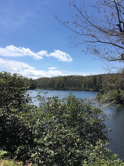
Day 1 was now in the books – 13.8 miles – the most miles I have done in a day in over a year. While I was nursing my aches and pains beside the lake, I was so thankful to be back out on the trail. This past year has been a tough journey. Hiking ‘centers’ me or to be more specific, allows my faith to be regenerated as I clear out all the distractions and are able to reconnect with my Creator.
DAY 2: Cone Manor to Thunder Hill Overlook

Day 2 was a special joy for me because I got to get back on the trail with Jack Petty. Jack is a great man and it is a pleasure to know him not just as my father-in-law but also a wonderful friend. Our last hiking adventure was about 30 years ago when we backpacked down from Wiseman’s view and spent a night in Linville Gorge. A lot has changed since then.

I had previously hiked from Shulls Mill Road to Cone Manor during the 40 Hike Challenge. You can read it about it here. We started our hike on Day 2 from Cone Manor heading east. The first 4 miles is a steady downhill on a rough gravel road (Wadkins Rd) which is open to equestrian use as well.

Traveling down a road with a friend is a blessing, especially when you can reminisce and share in the gratefulness of a wonderful family. There are times when it is good to be alone, but being outdoors is enhanced when it can be enjoyed with someone else.


After about 4.0 miles on the gravel road, the MST comes out at 321. There is about 0.1 mile stretch where you have to walk on the side of the road to reach the Blue Ridge Parkway ramp. From this point, the downhill stretch is over and the trail follows the Parkway up to Thunder Hill Overlook – an ascent of approximately 400 feet in a little over 2 miles.


The trail topography changes yet again as it traverses active pastures. From the 321 intersection to Thunder Hill, I went over approximately 6 ladder-stiles. These small sections of ladder-like fence have been designed with one side taller than the other. This allows one to grab the longer arm and swing your legs over the other side.
All of the cattle that I met were curious, but they safely kept their distance. We are grateful that these landowners allow us to share their property and we should go out of our way to respect their land and animals as well.

My day 2 hike from Cone Manor to Thunder Hill was right at 6 miles and is accessible from the parkway for an enjoyable day hike.
DAY 3: Thunder Hill Overlook to Grandview Overlook


I began Day 3 at Thunder Hill Overlook continuing east. The MST immediately gives you a taste of what the next few miles of Segment 5 will entail. Overall, the trail stays close to the parkway and it traverses over/under or beside it about 11 different times in the next 10 miles. I highly recommend that you wear some type of blaze orange. Some of the road walks here are pretty tight and drivers can be distracted with views and other things.
This section also consists of a lot more stiles and pastures. In these cases, the blazes may not be visible within the fields. Typically, if you cannot see the foot path, it will follow closely to the fence. However, I highly recommend that you download an app, such as FAR OUT or download the latest Trail Guide from the MST website.


There are also a couple of short sections on other roads other than the parkway. George Hayes Rd (at Aho Gap). This road walk is only about 0.5 mile, but there is very little area to walk – so again be careful. The trail is on Bamboo Rd for about a mile. This is an active gravel road through a residential area, but I had to step well off the road when meeting two different tractor trailers.


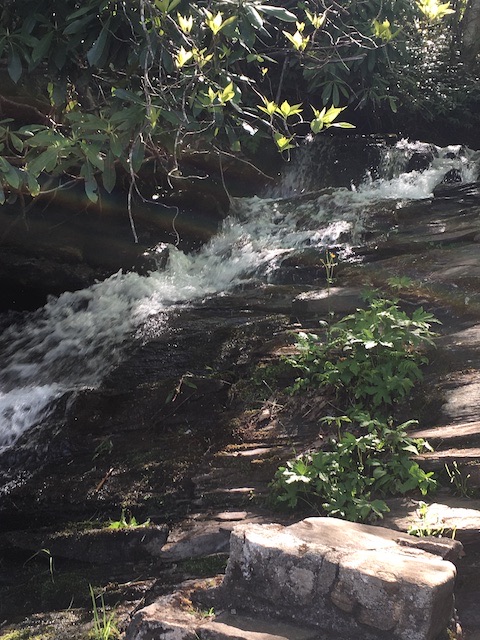
Just before Bamboo Road the trail meanders beside Goshen Branch. This is a great place for lunch and to explore. As soon as the trail leaves the creek, it’s stile hoping time again!


The hike from Thunder Hill Overlook to Grandview Overlook is 10 miles over easy terrain with many road crossings and pasture treks.
DAY 4: Shulls Mill Rd. Trailhead to Julian Price Park


This is one of my favorite hikes within Segment 5. On my last day of hiking, I went back to catch a few miles of the MST that I had previously missed. One of the benefits with day hiking is getting to choose which direction to hike. I chose to hike west from Shulls Mill Rd to Julian Price Park – ending my last day where I ended day 1.
The majority of the MST here follows the Boone Fork Trail, a 5 mile loop that follows the Boone Fork.


The Boone Fork Trail has numerous water crossings and ample opportunities to get out onto the water, rock hop, and enjoy the solitude. As the trail continues along the river, it reminds me of much of Segment 4- especially around Hunt Fish Falls. The Boone Fork Trail is accessible from Julian Price Park, and it is a popular destination.


My day 4 hike was 5 miles long and it was a pleasant capstone to 4 days of hiking Segment 5 of the MST. I look forward to continuing eastward in Segment 5. I also have a few areas to pick up in Segments 1 & 4.

As I had mentioned above, the past year took me off the trail for a while. One of the issues that I had to battle with, that I believe a lot of hikers find as a challenge, is letting go of unrealistic goals. I am a physicist and engineer so I am all about milestones and checklists, but life doesn’t always fit into our formulas. This year I am trying to learn more about taking each day and trail as it comes. It is okay to let go and see where it leads.
One Final Note:


In early April, I had the pleasure of joining my wife, Kimberly, at Banoak Elementary School in Vale, NC. Kimberly attended Banoak Elementary and this was her debut presentation for her Heelda the Cat series of books. I wrote about her books in a previous blog that you can find here or on her website – Heeldathecat.com. We spoke to more than 200 students from ages K – 6th grade over two days.
I also had the opportunity to share in the presentation with the book “Hiking Safety”. I was grateful for this platform to get children excited about being outdoors in safe and practical ways. I believe that if kids have a fun, safe experience in nature, they will learn to love it and protect it.
Hike it! Love it! Protect it!
40 Hike Challenge Blue Ridge Parkway Conserving Carolina Falls Lake Heelda The Cat Hickory Nut Gorge Hiking Jones Gap State Park Lake Lure Linville Gorge Mountains to Sea Mount Mitchell North Carolina Trails Rumbling Bald SC Trails Wilderness Gateway State Trail