
I will go ahead and tell you now, there’s going to be a lot of pictures ! As I have stated many times before, Segment 4 is my favorite and Linville Gorge is one of the reasons why. I grew up less than 30 minutes from the Shortoff Trailhead and I can still remember the drives up Wolfpit road in my dad’s old Ford Bronco. The area surrounding the gorge, specifically Lake James has seen some dramatic changes over the years with many high-end housing developments and the creation of the Fonta Flora Trail. However, the beauty and serenity of standing on top of Shortoff and looking up the gorge still sparks a spiritual renewal deep within my soul.

This hike has been on my wishlist for a long time. As we were planning, we knew that a beautiful Saturday in April would bring out the crowds. The parking areas at Pinnacle Trailhead and Wolfpit Rd are small and can quickly get overcrowded. So we had one choice – start early. We dropped a car at Wolfpit Trailhead and were rewarded for our early rising, with a beautiful sunrise as we approached the parking area at Pinnacle (off NC105).

We had another quick reward – The Pinnacle ‘peak’ is only 0.2 miles away from the parking area. This rocky observation area offers breath taking views in all directions. It is hard to believe that the vistas will get any better – oh, but just wait !

The trek from the trailhead down to the Linville River is about 3.0 miles with a steady elevation drop of just over 1500 feet. The path has been frequently traveled and is well blazed. With our early start, we had the trails to ourselves.

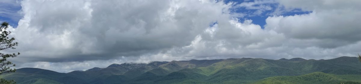
We were encouraged along the way with spectacular observation points of our destination and the gorge beyond.


In a previous post, I described my trip from Tablerock to Shortoff, an out-and-back hike. By placing cars at the Wolfpit & Pinnacle trailheads, we were able to plan this hike with the least amount of backtracking. Starting at Pinnacle – descending to Linville River (about 1500′) then ascending a quick 1700′ up the other side of the gorge to Shortoff and then going back down that trail to the WolfPit trailhead for a total of about 9.5 miles.

We reached the river at 9:30am and even though the temperature outside was warm, the water temperature, was – well, very cold ! Since we had several days of rain, we verified that water rates were safe by checking the USGS website. This is a very convenient website for planning trips with water crossings. Also, you can set up text or email alerts for custom water alerts. The general consensus is that for crossing the Linville River at this spot, the safe rate is below 200 ft/sec. If you are planning on crossing the river further north, then the rate needs to be much less. When we crossed it was around 145 ft/sec.

The crossing is about 80 yards wide and is clearly marked by large, round, white bucket lids nailed to trees. Today the water was about shin to knee high – and cold! It’s an easy trek but with lots of rocks so it requires some diligence. We ended up walking up-stream, due to the deep pockets near the bank edges.


After the river crossing we took time to dry off, change our shoes, and prepare for the sharp ascent up to Shortoff.

A few years back, this side of the mountain experienced a wildfire. Now the maple saplings and tulip trees are starting to reforest the area. Meanwhile, our destination loomed large ahead.

Just under 2.0 miles from the river bed we were rewarded with some of the first vistas of Lake James to the south. The morning mist was beginning to rise about the lake and with the recent rains, the forest greens were spectacular.

It did not take long to reach the south edge of the gorge. As we continued across the ridge toward Shortoff the views continued to get better and more breath taking.

One of the fascinating things about Shortoff is the pond that is a signature landmark after rains. Today the chorus of toads were serenading their potential mates. By mid afternoon, the trail became more crowded as day hikers and weekend campers began to scramble for pictures and lunch spots. The Wolfpit trailhead is less than 2 miles from the summit, so it makes for an easy day hike.

There are numerous places to explore, but no doubt about it- this is a dangerous place! If you plan on visiting with children, please keep a close watch. This is a wilderness, and one mistake would be tragic.

I know it sounds cliche’, but words and pictures cannot describe the beauty of this place. My friends and family hear me say many times that this is my “Happy Place”. As a hiking friend of mine said: “this shows that there really is something else to life. . . “


40 Hike Challenge Bladen Lakes Blue Ridge Parkway Conserving Carolina Eno River Falls Lake Florence Nature Preserve Heelda The Cat Hickory Nut Gorge Hiking Jones Gap State Park Lake Lure Linville Gorge Mountains to Sea Mount Mitchell North Carolina Trails Rumbling Bald SC Trails Wilderness Gateway State Trail
Thank you for sharing. What a beautiful hike.
Always enjoy your posts, the commentary and photos are spot on!! You need to write a book when you finish the Mountain to Sea
Trails. Looking forward to your next post!!