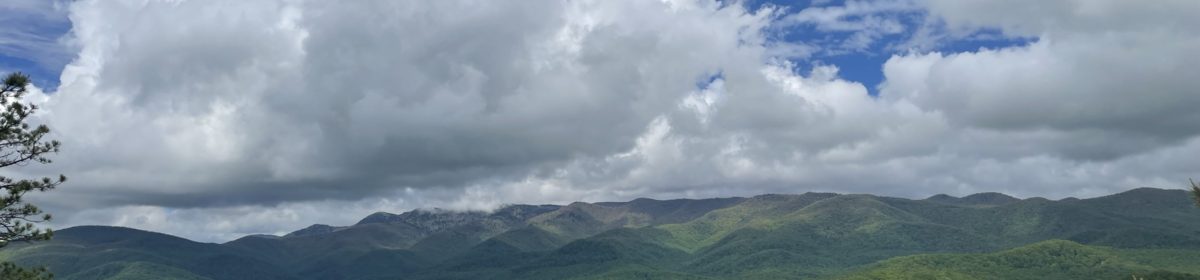

Segment 10 of the Mountains to Sea Trail extends 79 miles from the Eno River State Park to the Falls Lake Dam. This section is currently one of only a handful of segments that is all footpath as it follows the Eno River and eventually to the perimeter fingers of Falls Lake. Even though it weaves through many urban areas, the trail quickly immerses the hiker into a diverse experience of woodlands, fields, bluffs and great opportunities to view wildlife. This was my first multi-day hike on the MST, even though I was still breaking this down into long day – hikes. My plan over the next 3 days was to see how far we could go each day while still taking the time to enjoy the journey.

The Eno River is packed with history and there are many reminders to explore along the way. Many years prior to European settlers, tribes of the Eno, Occoneechee, and Shakori lived along the banks of the river. As the new country was developing in the 1700’s, many colonists took advantage of the abundant water source and established villages and mills along the Eno.
The Eno encompasses a rich and proud history. One of the best places to witness this is during the annual Festival for the Eno. This is a premier Folk and Art festival that has been active since 1980 to raise awareness and funds to support the Eno River. This event is sponsored by the Eno River Association whose work is a testimony to all of us who love the trails.

The Eno River Association rose up in the late 1960’s as a group of energetic and concerned community members opposed to the building of a reservoir and potential dam on the Eno. Through hard work, perseverance and critical alliances, they were able to spearhead the creation of the Eno River State Park. They are still active and crucial today as they continue their dedication to conservancy.

The 0.0 mile marker (east bound) of Segment 10 begins at the Pleasant Green Rd. Trailhead in the Eno River State Park where there is plenty of parking. At this point, the MST runs concurrently with the Laurel Bluffs Trail. (If you are interested in visiting the Eno Park Office, the facility is located on 6101 Cole Mill Rd.) A unique aspect of Segment 10 is it’s proximity to waterways. For the first 15 – 20 miles, it winds closely to the Eno, and for the remainder it skirts the shores of Fall Lake and its associated tributaries.

I was fortunate to share this trip with my college roommate, Cameron. It had been 35 years since we had been able to spend this kind of time together. Time flew as we reminisced and caught up on our journeys. As I always say, the trail is a wonderful place for conversation. Cameron has a wonderful talent and passion for photography. I encourage you to check out his work on Instagram. @CameronHFowler

We finished up day 1 of our hike at mile 10.4 and West Point on the Eno Park. This is a very active area with easy access to a 2 mile stretch along the Eno as well as picnic shelters, facilities and ample parking.

On the second day of our trek, we started at West Point on the Eno (mile 10.4) and we had the pleasure of being joined by our sons, Noah and Trevor. Both are working and going to school in the Durham area and so it was the perfect opportunity for fathers and sons to share some quality time in the outdoors. Plus, I am sure they were entertained by having to listen to all of our old stories – again.

As the trail leaves West Point, it meanders behind some housing areas which gives it more of an urban greenway feel. It soon returns to the wooded areas, and at this point the river is noticeably narrower and slower moving. At roughly 4 miles in on this hike, the Eno River creates a sharp bend which creates a peninsula. This natural area is known as Penny’s Bend Nature Preserve. It is 84 acres managed by the NC Botanical Garden.


An abundance of water tends to yield ample opportunities to experience wildlife. After the sun came up, turtles were numerous as they basked on logs and rocks. Blue Herons were also easy to spot up and down the river.

I think the uniqueness of Segment 10 is that it is a strategically placed trail within close distance of many urban areas, yet it maintains the feel of being in the forest. There are reminders as you go along that others have gone before us and shared this space for other uses. Overall, the trail is well maintained and easy to follow with clear blazing at all the intersections. I have noticed on the MST website that the Segment 10 Trail Crew is a busy and well organized group of volunteers. They continue to do a great job. Thank you !

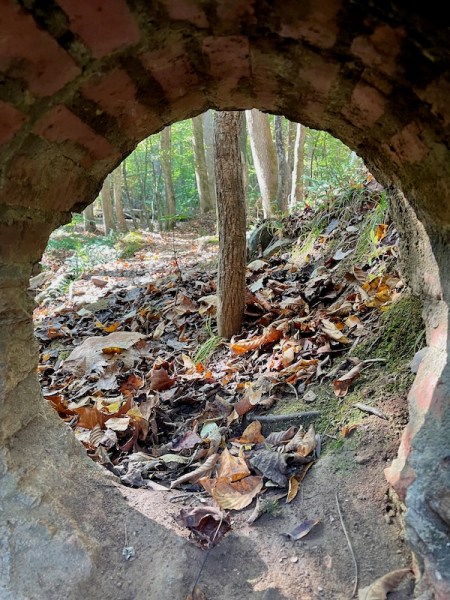
The picture above is of an old trestle that had been used to cross a small tributary from Falls Lake. I thought it was important to include this image to drive home the message that WE ALL LIVE DOWNSTREAM. I am not sure the picture does it justice, but it shows an obscene amount of plastic water bottles and other debris that has washed down into the creek. The trash probably had a long journey to end up here. However, it would be a difficult job to clean up and it’s unfair to expect trail crews to risk injuries and to pick up other’s trash. We obviously need to do more to educate those all around us about keeping the environment safe, clean and habitable.

We finished our 2nd day of hiking at Red Mill Rd – South Trailhead (Mile 24.2). Segment 10 offers plenty of access points for the trail and most of them have at least some limited parking. In planning our 3 days of hiking, we had to do a lot of coordinating to place cars in appropriate spots. If you are looking to car shuttle, I recommend reviewing the latest MST Segment Guides and the interactive map from the website. Note that some of the parking areas (especially the ones on Red Mill Rd) have very limited parking and can fill up fast on weekends.

On Day 3 we began our hike at Red Mill Rd South Trailhead. One note about road crossings – in our 3 days of hiking I counted roughly 12 road crossings. The crossings are typically on 2 lane roads, but there are some occasions where we had to walk on a short bridge with no walk path. In these cases, the road or bridge was typically blazed with obvious white circles that we’ve all grown to love. Be sure to exercise caution; walk facing the traffic and make yourself obvious.


From Red Mill Road, Segment 10 skirts all of the outcroppings of Falls Lake so that you are always close to some type of water view. Falls Lake is a 12,000 acre reservoir that was created in 1978 to aid in flood control of the Neuse River. It is part of the NC State Park system and provides recreational use as well as fish and wildlife conservation.
Along with abundant wildlife, there are many other diversions along the trail.

It is easy to see why Segment 10 of the MST is so popular. The trail is easily accessible from so many areas and it’s a gentle walk with mild elevation changes and a diverse habitat to explore. There are also many great spots to rest, eat or ponder.

We finished our 3 days of hiking at mile 37.2 and the footbridge over Little Lick Creek. It was only about 5 months ago that I was here hiking Hike #22 of the 40 Hike Challenge. Since then, I have completed the 40 Hike Challenge and am now enjoying section hiking the remainder of the MST. My journey now will take me back home to the mountains, as I continue my pursuit.
40 Hike Challenge Blue Ridge Parkway Conserving Carolina Hickory Nut Gorge Hiking Lake Lure Linville Gorge Mountains to Sea Mount Mitchell North Carolina Trails
Very nicely written, Tom. Thanks for a fun time!
It was a memorable trip and I look forward to the next one!
Wonderful narrative and beautiful pictures. I’ve hiked a good part of the MST along the Eno. Looking forward to more hiking heading east.
Thank you Celeste! It was great to actually meet you at the Gathering of Friends.