
This hike has been on my to-do list since I began day-hiking the MST and the 40 Hike Challenge a year ago. I have heard a lot about the Old Mitchell Trail that extends down 6 miles from Mt Mitchell to the Black Mountain Campground. My father and uncle have shared with me their summer camp stories near the South Toe River and and their hikes on the momentous trail to the summit of Mitchell. But today would mark a milestone for me as I officially complete Segment 3 of the MST.


I previously hiked to the Mitchell summit (Eastbound) and now I wanted to hike from Mitchell down to Black Mountain Campground and beyond to the Blue Ridge Parkway. As I have said before, day-hiking provides a lot of challenges for shuttles unless you are interested in an out and back. I was more intrigued with doing a longer hike in areas I had never explored. Thankfully, my wife and In-laws were gracious to provide shuttle services this past Saturday.

I started the hike at the fog covered Mt. Mitchell parking area around 8:00am. The weather forecast was calling for another hot day and I wanted to get an early start. The Mountains to Sea Trail crosses over the paved summit walking area and quickly exits into the Spruce and Fir forest that is endemic to this altitude. Even at this time, the area was starting to populate with hikers just setting out for various options that are available. Because I am used to solo hiking, the 8 to 10 hikers I met within the first hour seemed like a lot to me.
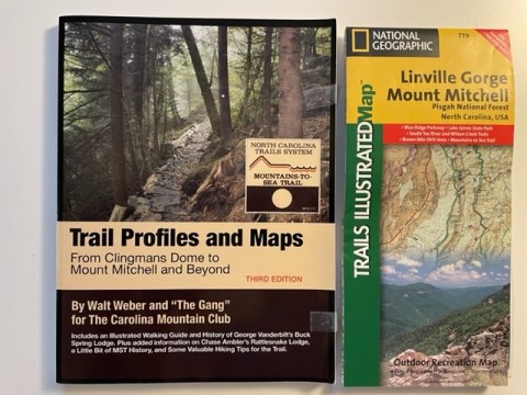
If you have an interest in hiking any of the Mountain Segments of the Mountains to Sea Trail, I highly recommend that you obtain a copy of Trail Profiles and Maps – From Clingmans Dome to Mount Mitchell and Beyond, by Walt Weber and “The Gang”. This is a valuable resource along with the latest USGS map of the area. The work that these gentlemen have done is remarkable. No detail is missed. While this book is crucial, it should not replace an actual map & compass. I also recommend some type of GPS device / app as well.

The trail begins its descent almost immediately. From the parking area it is 6 miles to the Black Mountain Campground with a change in elevation of approximately 3600 feet.

As you can see in the picture above, a lot of work has been done to ‘Keep the hiker on the trail and the water off’. The Carolina Mountain Club (CMC) maintains the MST from Clingman’s to beyond Mitchell to Buck Creek Gap. So far, I have had the opportunity to spend one Saturday working with the CMC crew and it was a thoroughly rewarding experience. I hope to join them again soon and I highly recommend that you check them out.

There are some rock scrambles on this trail, so be mindful to slow down and make sure each step has a solid grip – this is something I had to continue to remind myself of as well.

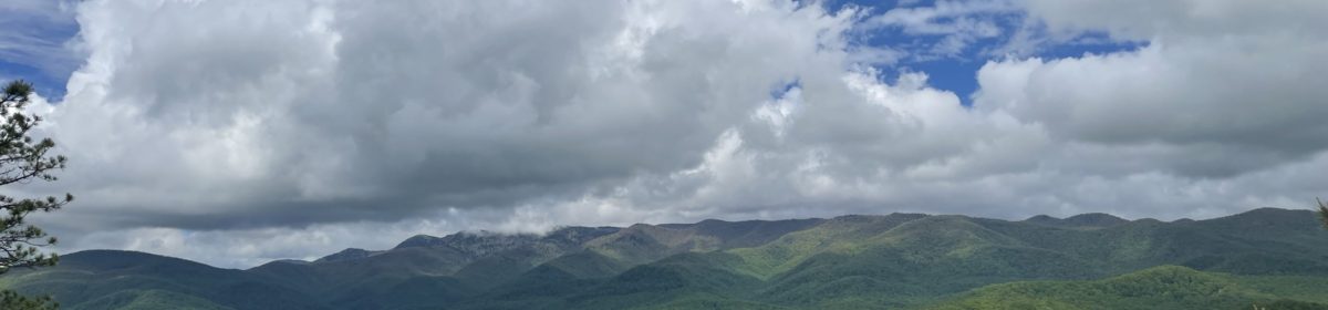
The foliage in this area is dense so the views are limited at this time of year. However, the thick cover was beneficial because within only a few hours the temperatures had increased significantly.

The MST crosses a powerline clearing several times during the descent and some spectacular views are available at these spots.

There are mileage and elevation posts conveniently located every 0.5 mile along the trail. At approximately 3 miles down the path, the Mitchell trail intersects with the Higgins Bald Trail, noted as TR190 and TR190A, respectively, on the USGS maps. On my older map (circa. 2006), the MST is shown as TR190. However, the latest MST Guides and the interactive map on their website as well as the MST App all indicate the southern route (TR190A) as the appropriate trail at this intersection. Both trails join back up further down the trail even though the Higgins Bald Trail may be approximately 0.4 miles longer.

When I first passed this intersection, my All Trails App was telling me I had gone off trail, but this was because I had previously entered the map points from the old map into All Trails. I was obviously on the right trail because the MST white, round blazes were prominent. I think it is important to note here why it is important to be familiar with where you are going; study the maps and carry more than one means of instruction. When I received the alert from All Trails, I immediately stopped and studied all of my resources to verify I was on the correct path. By the way, when on the MST, I always print out the latest Trail Update from the MST website. I also carry a Garmin GPS; phone; extra battery; MST App on the phone as well as a physical area map.

The 6 mile trek down to the campground was not as grueling as I had anticipated. I will admit that it did take a toll on my thighs, and I had to slow down to keep from tumbling over some rocks and roots. The next day I learned that there were 3 different bear sightings along the Mitchell Trail and in the campground, but I must have just missed them.

The Black Mountain Campground marked the milestone of completing the 71.4 mile long Segment 3. The campground has fresh water available, so it was an ideal spot to rest and replenish before completing 8 more miles in Segment 4. From looking at the MST guide for Segment 4, it was obvious that after about 1.8 miles, there would not be any other water sources for the remaining 6 miles of my journey.

The elevation change from the campground to my final destination was only about 400′, so the afternoon hiking would be much different than the morning steep downhill trek. This portion of the trail reminded me of the previous Segment 3 sections that I had hiked around Asheville, with deep Laurel and Rhododendron tunnels.

Within just a few hours, the hike began to really weigh me down. The temperatures had risen to the mid 80’s and even though there was some relief in the dense forest, I was sweating more than I had in a long time. I had carried a lot of water in and had been diligent about drinking, but I knew my body was telling me I was reaching my limits. I also spent about an hour walking in a summer thunderstorm. The raingear, heat and humidity really took their toll on me.
I finally reached the parkway at Singecat Ridge Overlook (MP 345.3). This offered me a great place to rest before I continued onto the final 2 miles to Buck Creek Gap. From the campground to Singecat Ridge is about 6 miles of deep forest. During this time I enjoyed the solitude of the woods, but I have to admit I was ready to see the Parkway on this sweltering day.

Before reaching my destination, the MST has to ascend to cross over the top of two tunnels, “Twin Tunnels #1 & #2”. The trail then continues down a series of switchbacks and crosses the BRP just before the intersection with NC80 (Buck Creek Gap).

This is where my hike would end today, but it is interesting to note that the MST leaves the BRP at this point and will not intersect it again until the end of Segment 4 at Beacon Heights, 68 trail miles away.

I have to admit that this hike really pushed me more than any other. The 14.4 miles along with the heat and humidity really took its toll on my body. Thankfully, I was prepared for the rain showers and had plenty of water (along with a filter), but before the day was done I had made a promise to myself: No more long hikes when the temperature is in the 80’s and above!
Overall, I am thankful to have completed Segment 3 and I will be going back to finish up my missing sections along Segment 1 and 2 during the remainder of the year.


40 Hike Challenge 2023 Year of the Trail Bladen Lakes Blue Ridge Parkway Conserving Carolina Eno River Falls Lake Florence Nature Preserve Heelda The Cat Hickory Nut Gorge Hiking Jones Gap State Park Lake Lure Linville Gorge Mountains to Sea Mount Mitchell North Carolina Trails Rumbling Bald SC Trails Wilderness Gateway State Trail
Congratulations on completing Segment 3!
Appreciate all your detail and advice. Congratulations on completing segment 3!
Thank you Celeste! I hope to post again soon.
tom